(meaning Deep Hole in Otjiherero)
(Namibia)
Index: Dive site | Treasure | Survey Map | Fish
Otjikoto is a dolomite sinkhole situated 18Km (11.25mi) north of Tsumeb on the Ondangwa road. The lake is on the farm Tsumore, belonging to Goldfields and is hired by Sieg Agenbag. To dive there one needs to obtain permission from:
Click here to see the full story and history behind Otjikoto.
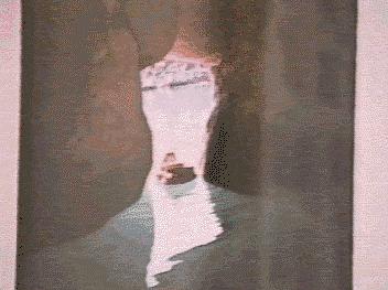
This is a photograph of the key hole cave from within the cave. This is quite a recent photograph. When I last dove there you had to descend about 5m below the surface to get into the cave. It had air inside then already. In recent years Namibia has had rather low rainfall and consequently the water table has dropped to the level you see here.
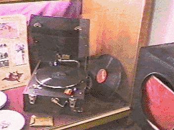
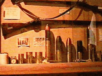
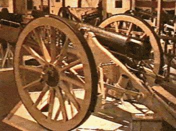
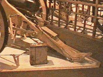
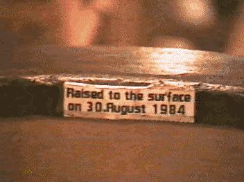
Towards the end of the first world war a contingent of German soldiers dropped a heap of equipment into the lake so that it would not fall into the hands of the enemy. No-one knows what precisely they threw, but we have seen a couple of cannon, lots of ammunition, odd artifacts and even parts of a Land Rover (not thrown in by the Germans). All the items below come from the Tsumeb museum.
 I wouldn't mind the nominal value of just one of these notes
now!
I wouldn't mind the nominal value of just one of these notes
now!
 Something
the Schutztruppe commander kept himself busy with while the waiting for the
war to end.
Something
the Schutztruppe commander kept himself busy with while the waiting for the
war to end.
 Click for
more cannons.
Click for
more cannons.
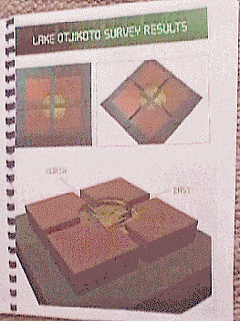
In 1995 four divers went up to lake Otjikoto near Tsumeb in Namibia to map out the lake as part of Bernd Tanneberger's 4 Star SAUU thesis. Below are 2 pages from the thesis and some pictures showing cross sections of the lake.
The measurements were made using a home made inclinometer on which was mounted a reliable echo sounder wired to a monitor on a boat on the surface. The device was lowered in steps of 5 meters (16.4ft), rotated through 360 degrees on the horizontal plain in steps of 22.5 degrees. This gave the lateral dimensions of the lake. To get the profile of the bottom the depth was pinged every 5 meters along a line radiating from the centre of the lake to the side. 16 such lines crossed the lake in increments of 22.5 degrees. (What a mouthful!)
The thesis contains 4 sections of the lake drawn in three dimensions and viewed from the top-down, horizontal and the bottom-up angles. These 12 pictures give a fascinating view of the lake. The two pages below give you an idea of what the 3D sections look like.

Click on the picture below to see the eight 2D cross sections of Otjikoto.

(The following is a quote from Infoweb)
This Endangered fish is known only from two sinkhole localities in Namibia, both of which are vulnerable to human interference and exploitation. They are Lakes Guinas and Otjikoto in the Tsumeb district. The lakes contain greenish [Otjikoto] and crystal clear [Guinas] water that seems to lack much food for fish, that available consisting of algae and items that fall into the water from outside sources. Threats to the Lake Otjikoto population include the introduction of alien fish, and the extraction of water for agriculture and mining at Tsumeb. Water from Lake Guinas is used to irrigate fields nearby, and pollution from the diesel pumps and agricultural insecticides is a potential threat to the fish population.
(To read more about the inhabitants of this fantastic place browse around Infoweb's enviro/ewtbook)

![]()
![]()